Friday, October 15, 2010

Viewing records tutorial

Sam Willyams demonstrates how to view records on NZBRN.

For this tutorial I will be demonstrating how to view records in various ways. The most important thing to remember is to start off with as few filters (species, location etc.) as possible, and then once you have an idea about what the data is like, you can filter it down further.

To begin with open the Biodiversity Recording Network website. There you should see 6 nice pictures of various life-forms each leading to a respective portal. You don't need to register or logon to view records and life will be easier if you wait. More...At the front page we'll click the bird portal to get started viewing records. Next we click 'show records' to open the view records wizard, don't worry if the page takes a few seconds to respond, it is working. When you move onto different portal, show records may be called under a different name such as query records; but the processes are all the same.

First up we are going to try finding all the tui records in the Wellington area. To do this we click “1. Select Species” type tui into the space and press enter.

You should see several varieties of bird named tui appear. If is says “no species found” then you may need to go back to the portal and logout. We will click on the encompassing tui selection at the top, click on the text to add it to our selection. At the top of the wizard you should see 'Species: tui'. Click on the text to remove the species if you've made a mistake. Now we've selected species, continue by pressing “3. Select Location”. For the time being we are going to skip '2. Select period', this means we will get data from any time in our final results.

Now your at select location, we want to filter the results down to those in just the Wellington area. There are several ways to do this, the first is to set region, district or ecological region to Wellington. The other way to do this is to click on 'google map' to select an area as you can see here...
At the top of the page there are several buttons to move the map to specific address (including most place names) or to the mapping references. Zoom in to an area around Wellington, you should start seeing blue markers appear, if you hover your mouse over them than the name of that location will appear. Once you've got the Wellington area in view, click the 'use this area' button to the bottom right to continue.

As we have selected both tui and the central Wellington area, we can click 'search' to continue. We now have a selection of ways we can view the data. Click on google map to get the observations displayed on a map. As you can see from the map, there are scattered sightings of tui more or less all over Wellington, although there are some places I know there are tui, yet no one has made a sighting yet, so the data is not a very good source of where tui are absent. Go back to the results page and this time click view as a list of records.

This screenshot shows a small sample of the results you should see. Following the name of the species is the number found, followed by the activity of the bird. Next is the location, click on the red text will bring up a map of the area. Next is the date and name of the recorder, by clicking on the name of the recorder you can bring up some contact details (if available) if you need to query them about the record. The encircled 'i' is lit up when a comment is available.

While this information may be useful to someone, I already knew there were tui present in Wellington, so now we are going to go back and find information about other birds , this time in the Karori suburb of Wellington. If you encounter any trouble with the second search, such as a mysterious absence of anything except tui in Wellington, then you may need to click on the main portal button and then go back into the bird portal to ensure the search is properly reset. Do this now to save time.

Now that our search has been cleared, we can go straight to location. We want to find all species so we need skip that section entirely. In the location screen,
go down to find 'common site by name', here we will type in Karori and see where it finds. Select the top result, 'Karori' in Wellington and check to make sure
it has appeared at the top of the wizard.

This time we will go to “other setttings” and click 'no' for Identification uncertain and Searched for, but not found. This will ensure our results are solid.

Now we click search and view results as a species list (third down on the left). This should bring up a list of 11 species which have been found in the area. The
list looks fairly short to me, so we may have had to expand the area to get more sightings. We'll try to get some more information, viewing as a list of records is generally the best way to do this, but as we've already done this we are going to view it as an excel file. Click view as file ready for excel. This gives us a page similiar to view results as list, but gives us a bit more information. Here we can see the exact numbers of each bird which were found, and we can also see that all the sightings came from a single source from the Garden bird survey.

This is all we're going to do, you should have a fairly good idea on how to use the core functions of the view records wizard, and you should be able to work out the remaining functions fairly easily now. Congradulations on finishing this tutorial. If you need any help then feel free to leave a message on this blog or on facebook.

Tuesday, October 12, 2010

Macrocarpa tutorial

Sam Willyams demonstrates how to enter plant findings into NZBRN.

For this tutorial we will be entering in a Macrocarpa sighting. It may be an
actual sighting or you may just follow along and not save it at the end. Macrocarpa is an exotic tree that can become a weed in native areas. It is also a fairly common shelter belt and aesthetic plant so be sure to mark your observation as "Cultivated" when it is not a wild plant.

Note that for plants, the number of plants can be recorded as a density per 100 m2 or a percent cover at the site or as a comment.

More...
To begin with open the Biodiversity Recording Network website. There you should see six nice pictures of various life-forms each leading to a respective portal. Before you can input a sighting you need to register and logon. To register, the button to do so is located above the fungi portal. If you've got ahead of yourself and are already in the plant portal then you can get back by clicking on "main portal" to the left of the top bar.

Follow the registration process, wait for an email then login. It is best to change your password now too. Click edit your profile next to logon, then click change password.

Note that the screenshots have been reused from the fungi tutorial so things might not look exactly the same.

Creating records:

To get started click the plant portal and then 'Create Record'. Be aware that the website may appear not to respond when you click a button. Don't worry, it usually just takes a few seconds before responding visually.

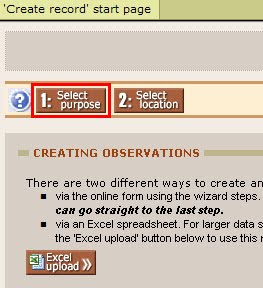
For this tutorial we will be enter just a single record so we'll click '1. Select purpose' rather than using an excel spreadsheet.

The first step is to create a purpose of the record. As you see by clicking the drop down menu, there are several purposes which you can select. These will show along with the records so whoever is viewing the records can know why or where from the record was created. You can make new purposes for yourself by clicking 'personal' on the top menu, then clicking 'my purposes' on the secondary menu inset from the top menu. It is not necessary to choose a record so we will leave this section empty. For the demonstration purposes, click the purpose drop down menu and click "Personal record". We now have purpose: 'personal record' displaying near the top. Click on the text to remove the purpose and continue onto location.

We'll get started by entering a location. In my instance I will be using the location I actually did find some macrocarpa. You may either use the location you found some or if you didn't, just enter any location you want (but be sure in that case to not submit. or delete, your observation at the end of this tutorial).

Start by clicking the google map button. Zoom in a few times with the scale bar or the wheel on your mouse. If you use your mouse wheel then the location of your mouse will be where you zoom in on. Otherwise you will have to hold left click and move the mouse to drag the map or click one of the arrows to pan the map. Once your close enough in, then a lot of blue markers will all over the map. These markers represent named sites across New Zealand and are fairly comprehensive. Unfortunately many markers aren't quite in the exact right spot (this is because the database that supplies these locations gives the coordinates of the map label in the standard New Zealand map series, which can be off to the side of a location). Don't worry about this. If the site exists then use that rather than one in the exact right location, as everyone knows where the real location is and the marker might get moved to the right location later. Hover your mouse over a marker to get its name.

Once you've zoomed in to the right area, we can make a new site like this one:


Note that I've numbered squares in the above screenshot. Here's what they do.
1. Finds an address and makes a new site there. Street addresses including abbreviations and place names all usually work. Note that it will make a new site even if that site already exists.
2. Finds a grid reference and makes a new site there.
3. We can name the site and use it or just save it as coordinates alone.

To make the new site by clicking, we just click on the place we wish to create the site. If you get the site in the wrong place we click somewhere else. As useful as the google map tool is, we encounter a slight flaw. Clicking to drag, making a new site and choosing an existing site all use the left mouse button. To avoid mistakes (in Internet Explorer), when dragging make sure you hold the mouse button for at least a couple of seconds. When making a new site, just click quickly and don't move the mouse, it will use grasp animation and may move the map slightly, but it should still make a new site in the right location. To choose an existing site, hover your mouse over a marker, the cursor should change to a pointing finger rather than an out-stretched hand. Wait to ensure the cursor is a finger before clicking, after a moment the information box should appear so you can click 'use this site'

If you are using a pre-existing site, this process is made much simpler by instead using search common site. Click on the name of the site from the resulting list select it. Check to make sure the right site has appeared at the top of the wizard.

I decided to use a pre-existing site (Quail Island) rather than a more accurate new site because this gives researchers the ease of finding all Quail Island records without the need to examine the map.

With the site selected, it should appear in text at the top of the wizard. You can continue by clicking 'create'.

Here we can fill in one or more sightings. Under taxon name (1.) type “Cupressus macrocarpa” or click on the taxa list button and type part of the name or a common name to find the appropriate name.

Once we are finished we'll click save. However first you should fill as much other information as possible, especially the density per 100 m2. You don't need to fill everything in the more you can do the better. Scrolling across the page, here is what you should see:

1. The little arrow is there to convert your nzmg (map grid) coordinates into NZTM coordinates. This is necessary as you may only input NZTM references.

2. The magnifying glass button will open a map with the location so you can check it. You can also click to mark a location. The check all markers button appears not to work.

3. Don't forget to check the dates, the default is the current date so unless you're imputing the data on the same day as you found it, it will be incorrect. The date is in YYYY-MM-DD format, so make sure you get the day/month the right way around.

4. Under comment I'm placing the number and precise location.

5. These are various additional options. Hover your mouse over them to get a description.

Finally if you didn't actually find some macrocarpa then we will make a personal comment stating “This is a fake recording”, so if you do make a record, everyone will know it's fake. (To delete or edit a record you've already entered, you'll need to go to the "Administrate records" page. The link for this is under the Show Records tab near the top of the window.)

Scroll over to the left and click save, unless you haven't found any yet, if that's the case just move away from the page.

Congratulations on finishing this tutorial. I hope you have a fairly good idea how to input records now. The plant species need not be a weed, they can be a native too, I just thought I'd get you started on something simple. If you need any help then feel free to leave a message on facebook or on this blog.

Monday, October 11, 2010

Species distribution maps, distributed

Jon Sullivan describes how web developers can add live NZBRN distribution maps to their webpages.

One of the fantastic things about the New Zealand Biodiversity Recording Network is that it can make distribution maps using Google Maps for all New Zealand species of birds, plants, mammals, fungi, reptiles, frogs, and (soon) invertebrates. The distribution maps are as extensive as the data entered into NZBRN. For common and charismatic species this means we already have thousands of points to map. For example, the following map is a live display of all bellbird observations in NZBRN. You can use this map just as if you were in NZBRN. You can click on the red "Show all markers / group markers" in the map to toggle on and off the clumping of points, zoom in and move about in the map, and click on any point for more information.


Distribution map of bellbirds (Anthornis melanura) in New Zealand.
View Larger Map | Enter your own observations
Source: New Zealand Biodiversity Recording Network.


The usual way to see these maps is to go to the NZBRN website, enter a Portal (for bellbirds, it would be the Birds portal), select your species of interest, push the search button, then select "Google map" from the options for displaying results.

What if you want to take one of these maps and add it to your own website? You can. Indeed, we encourage you to do this. Here is how.

More...

The following HTML code is what made the above bellbird map. If you paste it into your website, it should make the bellbird map.
<iframe width="525" height="800" frameborder="0" scrolling="no" marginheight="0" marginwidth="0" src="http://www.nzbrn.org.nz/birds/uttag_google.asp?art=506&art_leaf=False">Oops. Your internet browser does not understand iframes. You can view this map at the <a href="http://www.nzbrn.org.nz/birds/uttag_google.asp?art=506&art_leaf=False">New Zealand Biodiversity Recording Network (NZBRN) website</a>.
</iframe><br /><small>Distribution map of bellbirds (<i>Anthornis melanura</i>) in New Zealand.<br /><a href="http://www.nzbrn.org.nz/birds/uttag_google.asp?art=506&art_leaf=False">View Larger Map</a> | <a href="http://www.nzbrn.org.nz">Enter your own observations</a><br />Source: <a href="http://www.nzbrn.org.nz">New Zealand Biodiversity Recording Network</a>.</small>

What happens if you do not want a bellbird map? You will need to copy the relevant web address (URL) directly from NZBRN for your species of interest. You can get this by right clicking and copying the link for the "Google map" button in the results of any NZBRN search. That is what I was doing in the screenshot below, after searching on "kowhai" in the Plants portal and selecting to display the results for the genus Sophora L. (which includes all kowhai species).


Note that if you instead just click on this map link and load the map, a generic URL is displayed on the loaded webpage that will not work for copying or bookmarking. It's the same generic URL for any loaded map.

Once you've copied this link, you will need to paste it into my bellbird HTML code replacing my three bellbird URL with your own. Then, add that to your webpage and you should be good to go.

If you do this in several portals, you will see that the structure of the URL differs somewhat among portals. For example, the link to the map for kowhai that I got from the "Copy link" in the above screenshot is
which is a little different in structure from the bellbird URL in my first example,
NZBRN uses id numbers to refer to species in its web addresses. The bellbird in the first example is id 506 (and is referred to as "art=506" in the URL). The plant portal uses more elaborate ids for genera and species. In the above example, Sophora L. is id 79EA7DFA-5159-45B0-9221-726B272787C1. The easiest way to deal with this is as I described earlier. Just copy and paste the link for your species of interest from NZBRN.

Other than replacing out the three URL in my demo HTML code with your copied URLs, you can also change the width and height values. The next map displays the distribution of Sophora L. in New Zealand in a smaller space on the page.


Distribution map of kowhai (Sophora species) in New Zealand.
View Larger Map | Enter your own observations
Source: New Zealand Biodiversity Recording Network.


Here is the HTML for that map.
<iframe width="400" height="400" frameborder="0" scrolling="no" marginheight="0" marginwidth="0" src="http://www.nzbrn.org.nz/plants/uttag_google.asp?art=79EA7DFA-5159-45B0-9221-726B272787C1&standalone=false">Oops. Your internet browser does not understand iframes. You can view this map at the <a href="http://www.nzbrn.org.nz/plants/uttag_google.asp?art=79EA7DFA-5159-45B0-9221-726B272787C1&standalone=false">New Zealand Biodiversity Recording Network (NZBRN) website</a>.
</iframe><br /><small>Distribution map of kowhai (<i>Sophora</i> species) in New Zealand.<br /><a href="http://www.nzbrn.org.nz/plants/uttag_google.asp?art=79EA7DFA-5159-45B0-9221-726B272787C1&standalone=false">View Larger Map</a> | <a href="http://www.nzbrn.org.nz">Enter your own observations</a><br />Source: <a href="http://www.nzbrn.org.nz">New Zealand Biodiversity Recording Network</a>.</small>

NZBRN's implementation of Google Maps currently lacks some of the available bells and whistles. Most importantly, as you may have noticed in my kowhai example, it is not currently possible to set the zoom level or what part of the map is displayed. This means, for example, that it is not (yet) possible to display a live link to a map of the bellbirds of Canterbury. It also means that when you reduce the height and width values in the HTML code, you end up seeing a smaller and smaller part of the top left corner of the map. The map always is of New Zealand and always starts at the same initial scale. We hope to soon be upgrading the foundations of NZBRN and as part of this we will make this feature more flexible.

Friday, October 8, 2010

Fantail Tutorial

Sam Willyams demonstrates how to enter bird sightings into NZBRN.

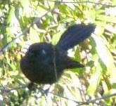
For this tutorial we will be entering in New Zealand fantail sightings. It may be an actual sighting or you may just follow along and not save it at the end. As you may or not know, fantails come in to visible forms, a coloured phase or a black phase. These are not different species or varieties but occur in the normal population right throughout New Zealand. One theory stipulates that that the black phase fantail is more common at higher altitudes. To help researchers, we can record fantails we see and if they are coloured or black phased.

More...


To begin with open the Biodiversity Recording Network website. There you should see 6 nice pictures of various life-forms each leading to a respective portal. Before you can input a sighting you need to register and logon. To register, the button to do so is located above the fungi portal. If you've got ahead of yourself and are already in the bird portal then you can get back by clicking on "main portal" to the left of the top bar.

Follow the registration process, wait for an email then login. It is best to change your password now too. Click edit your profile next to logon,
then click change password.

Note that the screenshots have been reused from the fungi tutorial so things might not look exactly the same.

Creating records:
To get started click the bird portal icon and then 'Create Record'. Be aware that the website
may appear not to respond when you click a button. Don't worry, it usually just takes a few seconds before responding visually.


For this tutorial we will be enter just a single record so we'll click '1. Select purpose' rather than imputing using an excel spreadsheet.

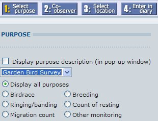
The first step is to create a purpose of the record. As you see by clicking the drop down menu, there are several purposes which you can select.
These will show along with the records so whoever is viewing the records can know why or where from the record was created. You can make new purposes for yourself
by clicking 'personal' on the top menu, then clicking 'my purposes' on the secondary menu inset from the top menu. It is not necessary to
choose a record so we will leave this section empty. For the demonstration purposes, click the purpose drop down menu and click "Garden Bird Survey". We now
have purpose: 'Garden Bird Survey' displaying near the top. Click on the text to remove the purpose and continue onto location.

We'll get started by entering a location. In my instance I will be using the location I actually did find fantails. You may either use the location you found some or if you didn't, just enter any location you want.

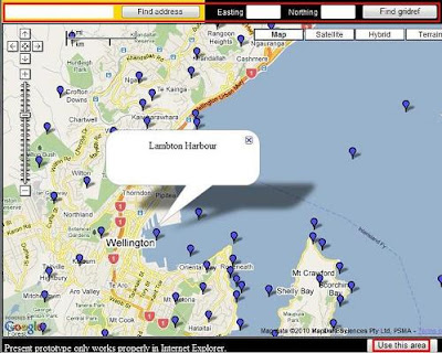
Start by clicking the google map button. Zoom in a few times with the scale bar or the wheel on your mouse. If you use your mouse wheel than the location of your mouse will be where you zoom in on. Otherwise you will have to hold left click and move the mouse to drag the map or click one of the arrows to pan the map. Once your close enough in, then a lot of blue markers will all over the map. These markers represent named sites across New Zealand and are fairly comprehensive. Unfortunately it seems that many markers aren't quite in the exact right spot. Don't worry about this, if the site exists then use that rather than one in the exact right location,
as everyone knows where the real location is and the marker might get moved to the right location later. Hover your mouse over a marker to get its name. Once you've zoomed in to
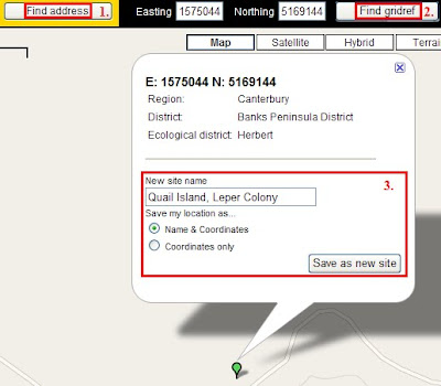
the right area, we'll make a new site like this one:

1. Finds an address and makes a new site there. Street addresses including abbreviations and place names all usually work. Note that it will make a new site even if it a site exists.
2. Finds a grid reference and makes a new site there.

3. We can name the site and use it or just save it as coordinates alone.

To make the new site by clicking, we just click on the place we wish to create the site. If you get the site in the wrong place we click somewhere else. As useful as the google map tool is, we encounter a slight flaw. Clicking to drag, making a new site and choosing an existing site all use the left mouse button. To avoid mistakes (in Internet Explorer): when dragging make sure you hold the mouse button for at least a couple of seconds. When making a new site, just click quickly and don't move the mouse, it will use grasp animation and may move the map slightly, but it should still make a new site in the right location. To choose an existing site, hover your mouse over a marker, the cursor should change to a pointing finger rather than an out-stretched hand. Wait to ensure the cursor is a finger before clicking, after a moment the information box should appear so you can click 'use this site'

If you are using a pre-existing site, this process is made much simpler by instead using search common site. Click on the name of the site from the resulting list to select it. Check to make sure the right site has appeared at the top of the wizard.

I decided to use a pre-existing site (Quail Island) rather than a more accurate new site because this gives researchers the ease of finding all Quail Island records without the need to examine the map.

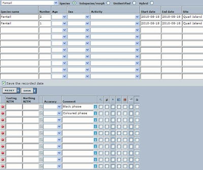
With the site selected, it should appear in text at the top of the wizard. You can continue by clicking 'create'. In a few seconds you should get a page such as this. Except I had to split it in two to fit on the page.

Here we can fill in one or more sightings. At the top of the page, we can scroll down a list of species to find “Fantail” and click on it to bring it up in the species box, or we could just type it in.

You should fill as much other information as possible. You don't need to fill everything in the more you can do the better. Scrolling across the page, you should enter in the number you saw.
Check the dates, the default is the current date so unless you're imputing the data on the same day as you found it, it will be incorrect. The date is in YYYY-MM-DD format, so make sure you get the day/month the right way around. Next make sure the site has carried through correctly.

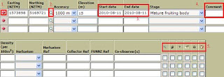
The little arrow is there to convert your NZMG (map grid) coordinates into NZTM coordinates. This is necessary as you may only input NZTM references.

The magnifying glass button will open a map with the location so you can check it. You can also click to mark a location. The check all markers button appears not to work.

At the far right are various additional options. Hover your mouse over them to get a description.

Finally if you didn't actually find some fantails then we will make a comment stating “This is a fake recording”, so if you do make a record, everyone will know it's fake.

If you did find some fantails, add a comment stating “Black phase” or “Coloured phase” depending on which you found. Now, if you've found both types then you need to go back to the left of the page and add fantail into the next taxon box. All the details from the last listing should copy down, except this time you can enter the other phase into the comment box.

Scroll over to the left and click save, unless you haven't found any yet, if that's the case just move away from the page.


Congratulations on finishing this tutorial. I hope you have a fairly good idea how to input records now. If you need any help then feel free to leave a message on Facebook or this blog.

Saturday, October 2, 2010

Amanita tutorial

Sam Willyams demonstrates how to enter mushroom/fungi sightings into NZBRN


The fly agaric (Amanita muscaria).
Photo by David Remahl
For this tutorial we will be entering in a sighting of Amanita muscaria (see picture to your right). It may be an actual sighting or you may just follow along and not save it at the end.

To begin with open the Biodiversity Recording Network website. There you should see six nice pictures of various life-forms each leading to a respective portal. Before you can input a sighting you need to register and logon. To register, the button to do so is conveniently located above the fungi portal. If you've got ahead of yourself and are already in the fungi portal then you can get back by clicking on "main portal" to the left of the top bar. Be aware that inactive accounts get deleted in about a week, so if you don't create a record soon then you'll need to make a new logon.

Follow the registration process, wait for an email then login. It is best to change your password now too. Click edit your profile next to logon, then click change password.

Creating records:


To get started click the fungi portal and then 'Create Record'. Be aware that the website may appear not to respond when you click a button. Don't worry, it usually just takes a few seconds before responding visually.

For this tutorial we will be enter just a single record so we'll click '1. Select purpose' rather than imputing using an excell spreadsheet.


More...The first step is to create a purpose of the record. As you see by clicking the drop down menu, there are several purposes which you can select. These will show along with the records so whoever is viewing the records can know why or where from the record was created. You can make new purposes for yourself by clicking 'personal' on the top menu, then clicking 'my purposes' on the secondary menu inset from the top menu. It is not necessary to choose a record so we will leave this section empty. For the demonstration purposes, click the purpose drop down menu and click "personal". We now have purpose: 'personal record' displaying near the top. Click on the text to remove the purpose and continue onto location.
We'll get started by entering a location. In my instance I will be using the location I actually did find some. You may either use the location you found some or if you didn't, just enter any location you want.

Start by clicking the google map button. Zoom in a few times with the scale bar or the wheel on your mouse. If you use your mouse wheel than the location of your mouse will be where you zoom in on. Otherwise you will have to hold left click and move the mouse to drag the map or click one of the arrows to pan the map. Once your close enough in, then a lot of blue markers will all over the map. These markers represent named sites across New Zealand and are fairly comprehensive.

Unfortunately it seems that many markers aren't quite in the exact right spot. Don't worry about this, if the site exists then use that rather than one in the exact right location, as everyone knows where the real location is and the marker might get moved to the right location later. Hover your mouse over a marker to get its name. Once you've zoomed in to the right area, we'll make a new site like this one:

1. Finds an address and makes a new site there. Street addresses including abbreviations and place names all usually work. Note that it will make a new site even if it a site exists.

2. Finds a grid reference and makes a new site there.

3. We can name the site and use it or just save it as coordinates alone.

To make the new site by clicking, we just click on the place we wish to create the site. If you get the site in the wrong place we click somewhere else. As useful as the google map tool is, we encounter a slight flaw. Clicking to drag, making a new site and choosing an existing site all use the left mouse button. To avoid mistakes (in Internet Explorer): when dragging make sure you hold the mouse button for at least a couple of seconds. When making a new site, just click quickly and don't move the mouse, it will use grasp animation and may move the map slightly, but it should still make a new site in the right location. To choose an existing site, hover your mouse over a marker, the cursor should change to a pointing finger rather than an out-stretched hand. Wait to ensure the cursor is a finger before clicking, after a moment the information box should appear so you can click 'use this site'

If you are using a pre-existing site, this process is made much simpler by instead using search common site. Click on the name of the site from the resulting list to select it. Check to make sure the right site has appeared at the top of the wizard.

I decided to use a pre-existing site (Quail Island) rather than a more accurate new site Quail Island, Leper Colony, because this gives researchers the ease of finding all Quail Island records without the need to examine the map.

With the site selected, it should appear in text at the top of the wizard. You can continue by clicking 'create'.


Here we can fill in one or more sightings. Under taxon name (1.) type “Amanita muscaria” or click on the taxa list button and type part of the name or a common name to find the appropriate name.

Once we are finished we'll click save. However first you should fill as much other information as possible. You don't need to fill everything in the more you can do the better. Scrolling across the page, here is what you should see:


1. The little arrow is there to convert your nzmg (map grid) coordinates into NZTM coordinates. This is necessary as you may only input NZTM references.

2. The magnifying glass button will open a map with the location so you can check it. You can also click to mark a location. The check all markers button appears not to work.

3. Don't forget to check the dates, the default is the current date so unless you're imputing the data on the same day as you found it, it will be incorrect. The date is in YYYY-MM-DD format, so make sure you get the day/month the right way around.

4. Under comment I'm placing the number and precise location.

5. These are various additional options. Hover your mouse over them to get a description.

Finally if you didn't actually find some Amanita muscaria then we will make a personal comment stating “This is a fake recording”, so if you do make a record, everyone will know it's fake.

Scroll over to the left and click save, unless you haven't found any yet, if that's the case just move away from the page.

Congradulations on finishing this tutorial. I hope you have a fairly good idea how to input records now. If you need any help then feel free to leave a message.